Western Land Acquisitions
What were the purpose, location, and impact of key United States territorial acquisitions?
 Image 1 - the Louisiana Purchase (yellow)
The Louisiana Purchase - 1803
In 1803, Thomas Jefferson wanted to buy the land around New Orleans, Louisiana from France. New Orleans was the port city that controlled imports and exports from the Mississippi River. He wanted to buy this land to help farmers along the Mississippi River who needed to transport their products down the river to the port in New Orleans and store them before export. It was too expensive for farmers to transport their products across the Appalachian Mountains to ports along the Atlantic Ocean. Jefferson decided to make an offer to buy the land around New Orleans from France for 10 million dollars. But before Jefferson could make the offer, France surprised Jefferson by offering him to sell the entire territory of Louisiana. The United States bought this land from France for 15 million dollars. This was known as the Louisiana Purchase. The Louisiana Purchase’s area covered all land west of the Mississippi River from present-day Idaho and north to Canada. When the U.S. purchased the Louisiana territory, it nearly doubled the size of the United States at that time.
In 1803, Thomas Jefferson wanted to buy the land around New Orleans, Louisiana from France. New Orleans was the port city that controlled imports and exports from the Mississippi River. He wanted to buy this land to help farmers along the Mississippi River who needed to transport their products down the river to the port in New Orleans and store them before export. It was too expensive for farmers to transport their products across the Appalachian Mountains to ports along the Atlantic Ocean. Jefferson decided to make an offer to buy the land around New Orleans from France for 10 million dollars. But before Jefferson could make the offer, France surprised Jefferson by offering him to sell the entire territory of Louisiana. The United States bought this land from France for 15 million dollars. This was known as the Louisiana Purchase. The Louisiana Purchase’s area covered all land west of the Mississippi River from present-day Idaho and north to Canada. When the U.S. purchased the Louisiana territory, it nearly doubled the size of the United States at that time.
 Image 2
The Florida Purchase - 1819
The Florida Purchase, also known as the Adams-Onis Treaty, was the result of conflict between New Spain and the United States. New Spain and the United States fought over the boundary lines of the Louisiana Territory. To resolve this conflict, Spain sold Florida to the United States in 1819 in exchange for 5 million dollars. This treaty also established a clear southern boundary between the Louisiana Territory and the New Spain at the 42nd parallel.
The Florida Purchase, also known as the Adams-Onis Treaty, was the result of conflict between New Spain and the United States. New Spain and the United States fought over the boundary lines of the Louisiana Territory. To resolve this conflict, Spain sold Florida to the United States in 1819 in exchange for 5 million dollars. This treaty also established a clear southern boundary between the Louisiana Territory and the New Spain at the 42nd parallel.
 Image 3
The Oregon Territory and Treaty - 1846
The United States claimed the Oregon Territory based on the explorations of Lewis and Clark. However, England, Spain and Russia had also previously claimed this area. At first, Americans in search of economic opportunity in fur trade moved into the Oregon Territory. The farmers that followed the fur traders wanted to be part of the United States. After much negotiation between the United States and England, the Oregon Treaty was developed as a compromise so the United States wouldn’t go to war with two different countries at the same time. Although some Americans wanted to claim land to the 54-40 line, most American settlements were south of this line. Therefore, in 1846 the United States and England compromised that the northern boundary of the United States would be set at the 49th parallel. This 49th parallel was an extension westward of the Treaty Line of 1818 that already established a boundary line between Canada and the United States.
The United States claimed the Oregon Territory based on the explorations of Lewis and Clark. However, England, Spain and Russia had also previously claimed this area. At first, Americans in search of economic opportunity in fur trade moved into the Oregon Territory. The farmers that followed the fur traders wanted to be part of the United States. After much negotiation between the United States and England, the Oregon Treaty was developed as a compromise so the United States wouldn’t go to war with two different countries at the same time. Although some Americans wanted to claim land to the 54-40 line, most American settlements were south of this line. Therefore, in 1846 the United States and England compromised that the northern boundary of the United States would be set at the 49th parallel. This 49th parallel was an extension westward of the Treaty Line of 1818 that already established a boundary line between Canada and the United States.
 Image 4
The Annexation of Texas - 1845
The Annexation of Texas happed nine years after the Texan War for Independence from Mexico. Before Texas gained its independence from Mexico, American southerners accepted Mexico’s invitation to move into the Texas territory. These American cotton planters that moved into the Texas territory agreed to become Mexican citizens, convert to Catholicism, and to follow Mexican law. They also agreed that there would be no slavery in Texas in order for the Mexicans to have access to this fertile land to grow cotton. However, when a new Mexican government came into power the Texans rebelled. In 1836, Texas fought a war to win their independence from Mexico. After gaining their independence, Texas wanted to become part of the United States. At first, the United States would not annex Texas because it would upset the balance of slave and free states. As a result, Texas was an independent country for nine years. When James Polk became President in 1845, the United States finally annexed (added) Texas.
The Annexation of Texas happed nine years after the Texan War for Independence from Mexico. Before Texas gained its independence from Mexico, American southerners accepted Mexico’s invitation to move into the Texas territory. These American cotton planters that moved into the Texas territory agreed to become Mexican citizens, convert to Catholicism, and to follow Mexican law. They also agreed that there would be no slavery in Texas in order for the Mexicans to have access to this fertile land to grow cotton. However, when a new Mexican government came into power the Texans rebelled. In 1836, Texas fought a war to win their independence from Mexico. After gaining their independence, Texas wanted to become part of the United States. At first, the United States would not annex Texas because it would upset the balance of slave and free states. As a result, Texas was an independent country for nine years. When James Polk became President in 1845, the United States finally annexed (added) Texas.
 Image 5
Mexican Cession - 1848
The Mexican Cession was a territory that the United States acquired as a result of winning the Mexican War. The Mexican War was the result of Manifest Destiny, the desire for Pacific ports, and the annexation of Texas. The United States wanted a port on the Pacific coast in the Mexican territory of California. President Polk tried to buy this land, but the Mexicans would not sell it. After Texas was annexed, the United States sent American troops into an area on the border of Texas that the Mexican government also claimed as their own. Shots were fired and the Mexican War in 1846. The United States invaded Mexico and defeated the Mexican army. The United States won the Mexican War in 1848 by taking the capital city. Americans also “helped” Mexican citizens living in California by declaring their independence from Mexico as well. The treaty that ended the Mexican War ceded Mexican territory in present-day New Mexico, Arizona, California, Utah and Nevada to the United States in exchange for 15 million dollars. This was known as the Mexican Cession. This land acquisition gave the United States access to ports on the Pacific Ocean. Soon, Americans discovered gold in California too.
The Mexican Cession was a territory that the United States acquired as a result of winning the Mexican War. The Mexican War was the result of Manifest Destiny, the desire for Pacific ports, and the annexation of Texas. The United States wanted a port on the Pacific coast in the Mexican territory of California. President Polk tried to buy this land, but the Mexicans would not sell it. After Texas was annexed, the United States sent American troops into an area on the border of Texas that the Mexican government also claimed as their own. Shots were fired and the Mexican War in 1846. The United States invaded Mexico and defeated the Mexican army. The United States won the Mexican War in 1848 by taking the capital city. Americans also “helped” Mexican citizens living in California by declaring their independence from Mexico as well. The treaty that ended the Mexican War ceded Mexican territory in present-day New Mexico, Arizona, California, Utah and Nevada to the United States in exchange for 15 million dollars. This was known as the Mexican Cession. This land acquisition gave the United States access to ports on the Pacific Ocean. Soon, Americans discovered gold in California too.
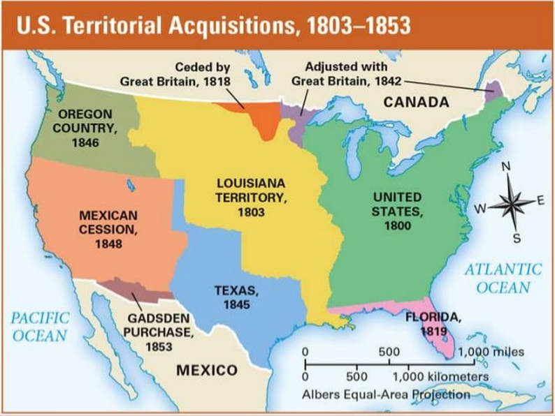
Image 6
Documents
| 4-5.3_western_land_acquisitions_notes.pdf |
| 4-5.3_western_land_acquisitions_notes.docx |
Sources
Text: ed.sc.gov
Image 1: https://upload.wikimedia.org/wikipedia/commons/5/57/Louisiana_Purchase.png
Image 2: https://upload.wikimedia.org/wikipedia/commons/thumb/9/96/Adams_onis_map.png/734px-Adams_onis_map.png
Image 3: https://upload.wikimedia.org/wikipedia/commons/0/09/Oregon_boundary_dispute_map.PNG
Image 4: https://www.learner.org/interactives/historymap/images/texas.gif
Image 5: https://sites.google.com/a/student.ucps.k12.nc.us/the-antebellum-period/_/rsrc/1463784142339/mexico/mexican-cession/mapmexicancessionwhitehouse.gif?height=256&width=400
Image 6: https://image.slidesharecdn.com/westwardexp201314-140213145325-phpapp01/95/westward-expansion-and-sectionalism-2-638.jpg?cb=1392303282
